

Table of Contents
The total station in surveying is an instrument that is primarily designed as a combination of electronic transit theodolite, an electronic distance meter (EDM), and software that runs on a computer which is referred to as the data collector.
The surveyor can use the total station for various purposes such as determining the angles, measurement of distances, etc.
Total Station is widely used in modern surveying, archaeology, mining, private accident reconstructions, etc.
✔ By the use of triangulations and trigonometric calculations; the measured angles and the distances can be used to determine the actual position of the required points or even the position of the total station from the known points in absolute terms.
✔ Most of the total stations these days consist of a GPS interface that combines the two aforementioned technologies.
The interface design is done such that the advantages of both the technologies are ensured (i.e. In GPS; the line of sight is not required between the consecutive measurement points.
While in the traditional total station; high precision measurement is required especially in the vertical axis in comparison to the GPS).
✔ The total station is the survey instrument that measures the angles by making use of the electro-optical scanning of the extremely precise digital bar-codes that are attached to rotating glass cylinders or discs present within the instrument.
The high-quality total station is even capable of measuring the angles down to 0.5 arc-second whereas the inexpensive total stations can mostly measure angles down to 5 or 10 arc seconds.
a. Working of Total Station
In the total station, measurement of distance is accomplished utilizing a modulated microwave or infrared carrier signal which is generated by a small solid-state emitter within the instrument’s optical path which is bounced back to the object to be measured. Then, the onboard computer provided in the total station reads and interprets the returning signal. The distance is then duly determined by receiving and emitting the multiple frequencies.
Most of the total stations consist of a purpose-built glass Porro Prism that serves as a reflector for the EDM signal and is capable of measuring the distance up to a few kilometers.
A typical total station’s EDM is capable of measuring the distance accurately up to about 3 millimeters or 1/100th of the foot.
Video: Robotic Total Station
Nowadays, the robotic type of total station is also in use. Such a type of total station allows the operator to control the instrument from a distance utilizing a remote control. This helps to avoid the need for an assistant staff member to hold the reflector prism over the point to be measured. It allows the operator to hold the reflector himself or herself and to control the total station from the observed point.
b. Principle of Total Station
The basic principle of the total station is that the distance between any two points can be known once the velocity and the time taken by the light to travel are known.
Distance = Velocity * Time
The following relation is already programmed in the memory of the total station along with the correction factors that are used to calculate the required horizontal distance and is finally displayed on the LCD screen of the instrument.
c. Objectives of Using Total Station
The major objectives of using the total station in surveying can be listed as follows:
a. To determine the angles between the points or average of the multiple angles measured.
b. To determine the horizontal distance between the points or average of the multiple distances measured.
c. To determine the elevation of various points.
d. To determine all three coordinates of various points.
d. Features of Modern Total Station
Some of the new features that the modern total station exhibit are as follows:
a. It is capable of surveying dark and wet surfaces even for long ranges.
b. It can conduct the surveying from the poles without the use of radios.
c. It is capable of measuring narrow objects as well as tight corners.
d. It can provide remote locations in case any point or unit is lost or stolen.
e. The software inbuilt in the modern total station is instant and can provide the firmware updates in the field itself.
e. Operations Performed by a Total Station
The important operations that can be performed using a total station can be listed as follows:
a. Measurement of Distance
An essential component of the total station is Electronic Distance Measuring (EDM) which is responsible for the distance measurement.
The measuring range of the EDM can vary from 2.8km to 4.2km.
A typical EDM is capable of measuring the distance with an accuracy ranging between 5mm to 10mm per km of measurement.
The EDM is equipped with an automatic target recognizer. The distance measured by the total station is always the sloping distance from the instrument station to the object.
b. Measurement of Angle
Another important operation performed by the total station is the measurement of angle.
Usually, any suitable direction must be taken as the reference direction for the measurement of the horizontal angles.
While, in the case of the vertical angles, the vertically upward direction i.e. the zenith is taken as the reference direction.
c. Processing of Data
The processing of data in the total station is done utilizing the microprocessor that is inbuilt into it.
The inbuilt microprocessor is capable of averaging the multiple observations taken.
The microprocessor can compute the horizontal distance as well as the location coordinates (X, Y, Z).
In the modern total station, the microprocessor can apply even the pressure corrections and the temperature corrections when the temperature and the pressure values are provided.
d. Display of Output
The output or the computed results are displayed in the total station utilizing the electronic display unit.
The display unit can display the computed horizontal distance, vertical distance, horizontal and vertical angles, elevation differences between points, and the location coordinates of the required points.
e. Electronic Record-Keeping (Electronic Book)
The total station is capable of storing the data in an electronic book which is similar to a compact disc of the computer.
Such an electronic book can store data ranging from 2000 points to 4000 points.
The data stored in the electronic book of the total station can be unloaded by the surveyor to a computer.
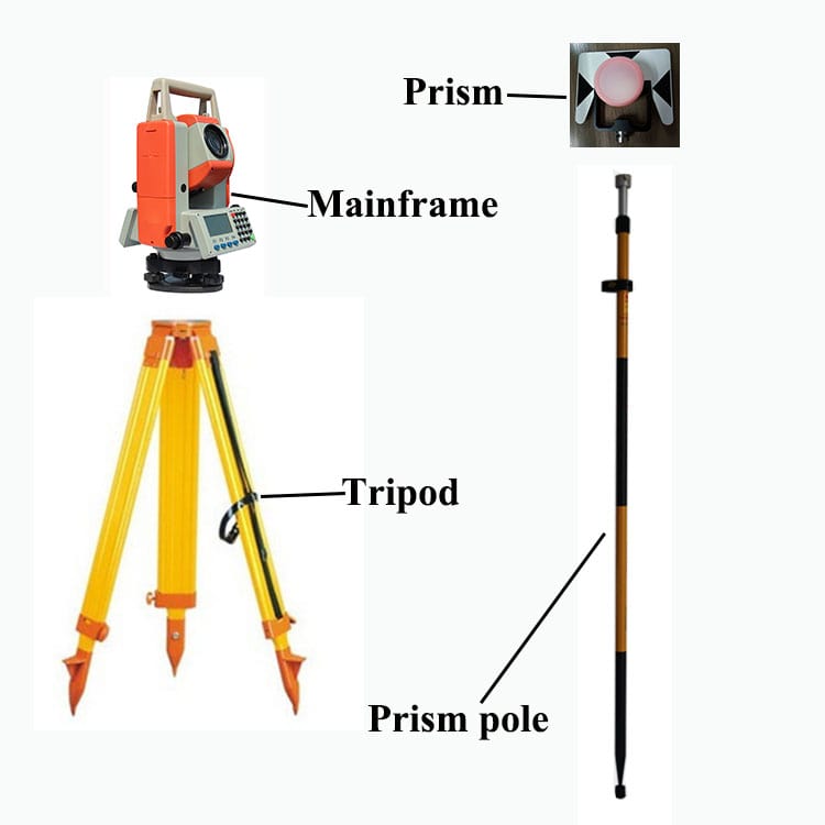
f. Components of a Total Station in Surveying
~ A total station comprises an EDM, theodolite, and an inbuilt microprocessor.
~ For storing the data, a memory card is also provided.
~ It consists of a battery that is provided in the battery socket.
~ A typical total station consists of the following components:
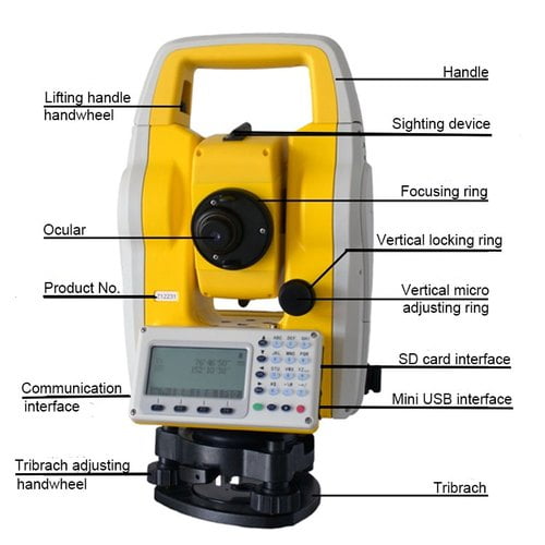
1. Handle
2. Handle Screwing Screw
3. Data Input/ Output Terminal
4. Instrument Height Mark
5. Battery Cover
6. Operation Panel
7. Tribrach Clamp/ Shifting Clamp
8. Base Plate
9. Leveling Foot Screw
10. Circular Level Adjusting Screws
11. Circular Level
12. Display
13. Objective Lens
14. Tubular Compass Slot
15. Optical Plummet Focusing Ring
16. Optical Plummet Reticle Cover
17. Optical Plummet Eyepiece
18. Horizontal Clamp
19. Horizontal Fine Motion Screw
20. Data Input/ Output Connector
21. External Power Source Connector
22. Plate Level
23. Plate Level Adjusting Screw
24. Vertical Clamp
25. Vertical Fine Motion Screw
26. Telescope Eyepiece
27. Telescope Focusing Ring
28. Peep Sight
29. Instrument Center Mark
g. Accessories of Total Station in Surveying
In addition to the major components, the total station also requires some additional accessories.
Such accessories include the keyboard, control panel, data collectors, reflectors, memories, etc which have been described in brief below.
a. Keyboard
The keyboard is an essential accessory required for giving the command to the microprocessor inbuilt in the total station as it contains various keys.
Such keys include command keys, switching keys, lighting keys, power keys, etc.
The different types of keys incorporated into the keyboard with their function have been listed as follows:
Power Key: To switch on or off the total station.
Star Key: To switch from one mode to another and to change the settings of the total station.
Illuminator Key: To turn on/off the laser pointer and the guiding light, to light the reticle as well as select the screen backlight brightness.
Esc Key: To return to the previous screen or cancel the input data.
Tab Key: To switch to another item.
B.S Key: To delete an item on the left side.
S.P Key: To input a blank space.
FUNC Key: To switch between the observations.
ENT Key: Select or Accept any input value or observation.
Shift Key: To switch between lowercase and uppercase characters.
Target Keys: To switch between the different targets.
PRG Key: To switch between different modes of the program.
b. Data Collector
As the name itself implies, the data collector collects and stores the observed data or observations.
The entire operation of taking in and storing the data is controlled by the data collector.
The data collector stores the data either in binary form or ASCII.
Data collectors can be further divided into external data collectors and internal data collectors.
c. Memory
The total station is equipped with inbuilt memory cards to process and store the data or observations.
The memory card provided in the total stations is generally up to the PCMCIA standards.
The memory card can have a capacity ranging from 5000 to 10,000 coded points.
The data held by the memory card can be unloaded on any computing device.
d. Reflector
The reflector is one of the most essential accessories of the total station. This is because the total station functions or takes the measurements utilizing the reflected rays.
The reflector comprises a specially built reflecting prism made up of cubes or blocks of reflecting glasses.
e. Software
In most of the total stations, the operating system used is Windows CE.
h. Suitability of Total Station
It is desirable to use a total station in surveying when any of the following conditions exist:
a. When two points have been provided.
b. When only one of the coordinates has been provided.
c. When no coordinates have been given and arbitrary sets of coordinates have to be used.
i. Accuracy of Total Station
The accuracy of a total station depends on the type of total station used. It is the degree of closeness between the measured value and the actual value.
Usually, the angular accuracy of a total station ranges from 1” to 20”.
The distance accuracy mainly depends upon the instrumental error and the error due to the length of measurement.
The instrumental error may vary between +/- 10mm to +/- 2mm.
The error due to the length of measurement may vary between +/- 10mm to +/- 2mm per kilometer in case of 1 prism, 2.5 to 2.7 km in case of two prisms & 5 to 7 km in cases of 3 prisms.
j. Least Count of a Total Station
In the total station; the least count of the angle is 1” (1 second) and the least count of distance is 1 mm.
k. Field Procedure of Surveying Using Total Station
The field procedure of surveying by total station includes the following series of steps:
a. Setting up the Tripod:
The tripod legs are adjusted such that they are spaced equally.
The head of the tripod must also be leveled.
The adjustment must be done so that the head of the tripod lies exactly over the station mark.
b. Mounting total station on the Tripod:
After the tripod has been set, the total station is then mounted on the tripod.
With one hand, the instrument is braced over the tripod while with the other hand, the centering screw must be secured.
c. Centering
Centering is the process of bringing the vertical axis of the theodolite exactly over the station mark. It is done by employing the optical or laser plummet.
d. Levelling the Total Station:
Then, the leveling foot screws are adjusted such that the survey point lies centrally on the optical plummet reticle.
The tripod legs are further adjusted so that the bubble lies centrally on the circular level.
Firstly, the bubble is aligned parallel to the two-foot screws and brought to the center by turning both the screws in the same direction.
Then, the bubble is aligned parallel to the remaining foot screw and brought to the center by rotating the screw.
The procedure is repeated until the bubble remains central in all directions.
e. Verifying the Leveling Electronically:
Firstly, the instrument is switched on by pressing and holding the “ON” button.
An audible beep is heard once the instrument is turned on.
After the opening screen is displayed, the function is selected.
The foot level screws are then adjusted so that the electronic bubble is also centered.
The instrument is rotated at 90 degrees and the process is repeated.
f. Adjusting the Image & Focusing the Reticle (Cross-Hair):
The horizontal and vertical clamps are then released and the telescope is pointed at any light background that is featureless.
Then, the reticle or the cross-hair is adjusted until the reticle image becomes distinctly focused.
The telescope is then focused on the target and the focus ring is adjusted until the target is distinctly focused.
The removal of parallax is then checked by moving the head slowly to one side.
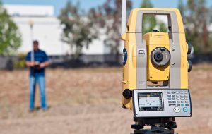
g. Taking the Measurements:
Once the above steps have been completed, the total station can be used to take the measurements or observations.
l. Uses of Total Station
a. Distance Measurement:
One of the most important uses of the total station is a distance measurement.
It can be used for the measurement of distance by employing a modulated carrier infrared signal. This signal can calculate the distance after it is bounced back or reflected by the object under consideration.
Such infrared carrier signal is generated by the total station employing a solid-state emitter and the interpretation of the reflected signal is carried out by using the computing chip inbuilt in the total station itself.
b. Angle Measurement:
Another important use of the total station is the measurement of angles between the points.
Such angular determinations are accomplished using the electrical and optical scanning system of the telescope. This system is provided with rotating glass that comprises the bar codes. Such glass makes it easier to read the angles.
In the case of digital total stations, the readings are directly recorded and stored in the main memory of the total station. The data stored can also be transferred to a computer.
c. Coordinate Determinations:
An essential application of the total station is to determine the location of the required points i.e. it can be used to compute the X, Y, and Z coordinates of the survey points.
d. Land Surveying & Alignment Surveying:
Land surveying can be done easily using a total station.
In land surveying, the total station can be used to measure the distances, angles as well as location coordinates which can be further used for the preparation of topographical maps and plans.
Total stations can also be used for demarcating the property lines and the boundary lines.
It can also be used for determining the alignment of canals, tunnels, roads, bridges, etc.
e. Mining:
Before the commencement of any mining work, a mining survey has to be done. The total station is an essential instrument used for this purpose. It can also be used to determine the mining points and to prepare the mining maps.
Such points and maps can be used by the miners to locate the points with abundant minerals.
The total station is also used for determining the location and the alignment of the mining tunnels.
f. Civil Engineering Construction Works:
Almost all types of civil engineering construction and related works can be done using the total station.
The total station can be used for the measurement of construction parameters such as distances, angles, elevations of points, coordinates, etc.
It can be used for the preparation of maps and plans, demarcating the property lines, land surveying, determining the alignment of roads, bridges, tunnels, etc.
g. Automatic Target Aiming:
Most modern total stations are provided with automatic target systems to increase the degree of efficiency of the total station.
Such a system is provided to ensure better and faster targeting and locating of any point on the surface of the earth.
The system is so quick that the entire process of measurement, processing, and computing of the distance, angles, and coordinates takes place very quickly within seconds.
Thus, the entire work can be completed easily and fastly.
h. Electrical and Mechanical Construction:
The layouts for the electrical as well as the mechanical constructions can be determined easily utilizing the total station.
Various works such as underground pipe laying, laying of utilities and cables, etc can be done using the total station.
m. Precautions to be taken while using a Total Station
The precautions that must be taken while using a total station can be listed as follows:
a. The total station must be handled properly and held by both hands.
b. The tripod must be held on a stable surface as far as practicable.
c. The battery pack must be stored with the battery discharged.
d. The clamping screws must not be tightened extremely.
e. The tripod with the total station mounted on it must not be carried from one station to another.
f. Care must be taken when the tribrach has been removed from the total station.
n. Advantages of Total Station
The total station offers the following major advantages:
a. The total station helps to complete the fieldwork quickly in a lesser period.
b. The setting up of the total station is also easier as it can be done easily by using the laser plummet.
c. The degree of accuracy of the total station is relatively higher than other survey instruments.
d. The computed values can be directly stored in the total station and can also be easily transferred to a computing device.
e. The total station is also advantageous in the computerization of old maps.
f. Since all the observations and computations are done digitally, error due to omission of data, wrong reading or noting of observation, etc is omitted.
g. It can also help in contouring and map preparation.
h. When the atmospheric pressure and temperature are provided, the pressure and temperature corrections can also be applied automatically.
i. The entire survey work and office work can be completed easily.
o. Disadvantages of Total Station
Some of the disadvantages of the total station can be listed as follows:
a. While using the total station, it may be difficult for the surveyor to recheck the work.
b. Skilled manpower or experienced personnel is required for operating the instrument.
c.The total station is costlier than other conventional survey equipment.
d. The total station is incorporated with several electronic accessories and parts that may be affected by moisture.
p. Remotely Operated Total Station (Robotic Total Station)
The remotely operated total stations are the modern type of total stations that are designed such that they can be operated by the surveyor from a certain distance utilizing a remote control.
The robotic total station is capable of automatically locating the target. It offers the highest degree of precision and accuracy among all types of surveying instruments.
The use of remote control technology prevents the need for a second person to hold the reflector. Only one surveyor at the target station is sufficient for taking the measurements.
Thus, robotic total stations reduce the number of personnel required for taking the measurements. It also increases the speed of work.
Some of the salient features of the remotely operated total station can be listed as follows:
a. Robotic total stations comprise a hassle-free cable-less design that can be handled easily.
b. Such total stations have an in-built quick-lock tracking technology.
c. The reflector system of the robotic total station is very powerful and has the longest range.
d. This type of total station consists of a field controller interface.
e. The robotic total station is lighter in weight in comparison to the conventional total stations. Thus, such total stations are portable and easy to handle.
f. The operating system of the robotic total station is advanced and offers enhanced graphics. Due to this reason, this total station is also known as a graphical windows mobile instrument.
| Read More: Tacheometric Survey |
| Read More: Grades of Concrete |