

Table of Contents
1. Introduction
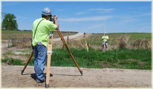
Levelling is defined as the branch of surveying that is essentially used for determining the relative height of the different points on, above and below the surface of the ground.
The basic principle of levelling is to determine the horizontal line of sight with respect to which the vertical distances of the points below or above this line of sight are determined.
In general, two types of levelling are used in engineering works i.e. direct levelling (spirit ) and indirect levelling (trigonometric ).
2. Objectives of Levelling in Surveying
1. To determine the elevation of the given points with respect to the given/assumed reference line or datum.
2. To establish the points at a provided elevation or at various elevations with respect to a given or assumed datum.
3. Applications of Levelling in Surveying
1. Levelling is necessary for the estimation and planning of various civil engineering works such as roads, bridges, canals etc. It is also necessary for the route or alignment survey of roads, bridges etc.
2. It is used to calculate the quantities of cut and fill as well as for balancing the earthworks.
3. Levelling is an important aspect of the pipeline survey as it is used to ensure a suitable slope of the land that will allow a smooth flow of the liquid inside the pipe.
4. It is also vital for the preparation of contour maps.
5. It is necessary for the preparation of topographic maps.
4. Types of Levelling in Surveying
a. Direct Levelling
It is the levelling in which the vertical distances with respect to a horizontal line is mostly used to determine the relative distance in elevation between the two adjacent points by means of an auto-level and staff.
A level is an instrument that provides a horizontal line of sight.
Line of sight is the line that is tangential to a level surface at the point where the instrument stands.
The difference in the elevation between the two points is the vertical distance between the two-level lines.
By setting up a level at any place, the difference in the elevation between any two points within the proper length of the site is given by the difference between the staff readings taken on these points.
Using such succession of instrument stations and the related readings, the difference in elevation between the widely separated points is thus obtained.
The direct method of levelling can be further classified into the following types:
a. Differential Levelling:
It is used to determine the difference in the elevation between two points irrespective of the horizontal positions and with respect to each other.
Differential levelling is also commonly referred to as Fly levelling.
b. Profile Levelling:
It is the type of direct levelling that is used to determine the elevations of the points at measured intervals along a line so as to obtain a profile of the surface along that line.
This method of levelling is necessary for the alignment surveys of roads, bridges etc.
c. Cross Section Levelling:
It is the levelling that involves the process of taking the levels on each side of the main baseline at right angles to that baseline so as to determine the vertical cross-section of the surface of the ground or the underlying layer or even both.
d. Reciprocal Levelling:
It is the type of direct levelling in which the difference in the elevation between the two points is determined by the two sets of reciprocal observations when the points are separated by large intervening spaces such as lakes, depressions etc.
2. Indirect Levelling
Indirect Leveling is commonly referred to as trigonometric levelling.
It is the type of levelling that involves the process in which the elevations of the points are computed from the vertical angles and the horizontal distances measured in the field, just as the length of any side in any triangle can be computed from the use of the trigonometric relations.
5. Temporary Adjustment of Levelling
The temporary adjustment of the level consists of the following series of steps:
1. Setting up the level:
The first step in the temporary adjustment of the level is set up of the level.
The setting up basically includes the fixing of the instrument on the stand and levelling the auto level approximately.
2. Levelling up:
Then, accurate levelling is done with the help of the foot screws with reference to the plate levels of the instrument.
Levelling is done so as to ensure that the vertical axis is truly vertical and the horizontal line of sight is truly horizontal.
3. Removal of Parallax:
Parallax is defined as the condition in which the image formed by the objective lens does not lie on the plane of the crosshairs.
It can be eliminated by focusing the eyepiece of the instrument until the distinct vision of the crosshairs is not obtained.
6. Two Peg Test
Two peg test is carried out to check or detect the collimation error of the level.
In this test, two staff are placed at two known points say A and B that are known distances apart usually about 50m.
The instrument is first set up at the line near B and both the staff readings (top, middle and bottom) are taken.
The instrument is then set up at the middle point say C on the line and both the staff readings on A and B is taken.
Then, the computation is done in order to check if the adjustment is within the required accuracy or not.
If the adjustment is within the required accuracy, permanent adjustment of the instrument is not required.
7. Booking and Reducing Levels
In common practice, two methods of booking and reducing the elevation of the points from the observed staff reading are used which are listed as follows:

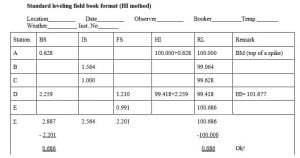
a. Height of the Instrument Method
In this method, two arithmetic check formulas are used i.e.
Arithmetic Check:
Sum of Back Sight Reading – Sum of ForeSight Reading = Last Reduced Level – First Reduced Level
b. Rise and Fall Method
In this method, the following arithmetic check formulas are used i.e.
Arithmetic Check:
Sum of Back Sight Reading – Sum of ForeSight Reading = Last Reduced Level – First Reduced Level = Sum of Rising – Sum of Fall

| Read More: Total Station |
| Read More: Tacheometric Surveying |