

Table of Contents
Plane table surveying is the graphical method of surveying that is carried out to prepare maps, plans and also to collect details(like topographic details) through field observations.
This surveying is carried out utilizing a plane table hence it is named as plane table surveying.
The plane table generally refers to the instrument that is used in surveying and provides a solid and level surface on which field drawings, maps and charts are made.
It is a fast and cheap method of surveying.
Another benefit of using this method of surveying is that the omission of observations is eliminated; as the surveyor directly plots the details in the field.
This surveying is a relatively fast method of surveying. The method employed is also simple and easy to perform.

2. Objectives of Plane Table Surveying
The main objectives of plane table surveying can be listed as follows:
1. To carry out small scale surveying rapidly.
2. To run the survey lines between stations that have been previously fixed by other methods of surveying.
3. To locate the topographic details.
4. To survey industrial areas where compass surveying is not feasible.
5. For the preparation of small scale maps.
3. Principle of Plane Table Surveying
The main principle of plane table surveying is based on parallelism.
According to this principle, all the rays drawn through the various details should pass through the survey station.
In this regard, the position of the plane table is kept identical in each of the stations. This is done by orienting the plane table in the direction of magnetic north in each station.
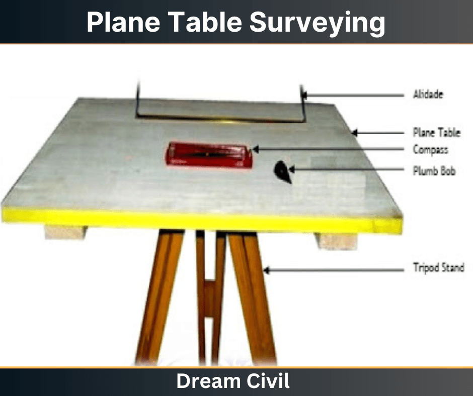
4. Equipment Used in Plane Table Surveying
The equipment used for plane table surveying can be listed as follows:
a. Plane table:
A plane table with a stand is generally required. The size of the table is 600 * 750 mm.
b. Compass:
It is required to measure the direction of the magnetic meridian.
c. Alidade for sighting:
It is used to bisect the object, draw rays, direction lines etc. It is simply a ruler with a sight line attached.
d. Plumb bob or plumb fork:
The length of the plumb bob is 50 mm and weight varies from 2 to 5 Newton. It is generally required for centring the table at a particular station.
e. Sprit level:
It is required to fix the table horizontally.
f. Chain:
It is used to measure the distances. It is composed of a 100 to 150 piece of galvanized mild steel wire 4 mm in diameter called links.
g. Ranging Rod:
It is used to mark the intermediate station.
h. Tripod:
It holds the plane table.
i. Drawing tools and drawing sheets:
Excellent quality drawing sheets are used to plot the survey details.
j. Paper clips and screw:
Paper clips are required to fix the drawing sheets in the drawing boards.
5. Temporary Adjustment of Plane Table
Generally, temporary adjustment can be understood as the set of operations that are performed to make the instrument ready for taking the observations efficiently.
The temporary adjustment of the plane table involves the following steps:
a. Centring:
Centring is the process of ensuring that the point on the ground is exactly represented on the paper.
It is done with the use of a plumbing fork or plumb bob.
First of all, the pointed end of the plumbing fork is kept on the paper while the other end is attached with a plumb bob.
Then, the board is continuously moved until the bob hangs exactly over the peg of the station.

b. Levelling:
Levelling is done to ensure that the drawing board remains exactly parallel to the ground surface.
It can be done by adopting one of the following methods:
i. Application of ball and socket arrangement.
ii. Tilting of the board ordinarily.
iii. Adjusting the legs of the tripod.

c. Orientation:
Orientation may be defined as the process of keeping the position of the board parallel at every survey stations.
Since the plane table survey requires moving of the plane table from one survey station to another, it must be oriented properly.
The new station has to be kept parallel to the previous station else the plotted lines may not exactly represent the survey lines on the field.

There are two methods of orientation that are commonly adopted. They are described as follows:
i. Orientation by Back Sighting
In this method of orientation, the survey line previously drawn from a previous survey station is redrawn from the new station. This is done to ensure that the line drawn on the new station superposes the line drawn on the previous station. It is a very reliable method of orientation.
ii. Orientation by Magnetic Needle
Orientation by the magnetic needle is adopted when bisection of previously drawn line from the new station is not feasible. Due to the variation of the magnetic needle, this method is not very reliable.
6. Methods of Plane Table Surveying
Most commonly four methods of plane table surveying are practised.
These methods are described briefly below:
i. Radiation
In this method, a point is selected and the entire survey is carried out regarding the selected point.
As shown in the figure below, one point O is first selected then from this point O other points namely A, B, C, D and E are sighted using an alidade.
Then, the points a, b, c, d and e are respectively located and sighted.

Figure: Radiation Method
ii. Intersection
Intersection method is most desirable in the mountainous or broken rough surface where the distances cannot be measured physically.
This method employs locating a point by plotting two rays from two known stations.
Let us consider the two known stations are P and Q.
Firstly, the plane table is set at one station, say P. Then, Q, A and B are sighted and lines are plotted.
Similarly, the table is set at next station Q and the stations P, A and B are sighted and lines are plotted. Thus, the intersection point of rays A and B is the required location of the point.

Figure: Intersection Method
iii. Traversing
Traversing method is adopted for running the survey lines between stations that have been previously fixed by other methods of survey.
It is similar to compass surveying.
It includes the following series of steps:
1. Firstly, the plane table is fixed at one station(say A) as shown in the figure below.
2. From this station, another station (say B) is sighted and the distance AB is measured.
3. Back sighting is then carried out. This involves setting up the table at station B and sighting A. The distance BA is measured.
4. The average distance computed between AB and BA is then plotted to a suitable scale on the drawing paper.
5. Similarly, another station C is sighted and the process is repeated at all stations.
6. Checking is done at suitable intervals. Finally, the traverse lines are plotted on the drawing sheet.

Figure: Traversing Method
iv. Resection
Usually, this method is adopted to determine the location of new stations to establish the missing details.
In this method, the location of a station is determined by sighting known points whose location has already been plotted.
The resection method involves two processes i.e.
1. Two Point problem
2. Three Point resection.

Figure: Resection Method
a. Two-Point Problem
In the two-point problem, the available two points are observed from other point corresponding to the points available in the plane table sheet.
Here two cases are to be discussed.
Case 1:
When the points can be occupied by the plane table As shown in figure below are the two points corresponding to the points a and b. Now, plane table is kept at B and oriented by observing A. Observation C from B and bx is drawn on the sheet.
Then move the plane table to station C, oriented by backsighting B along xb. Then alidade is kept over a and observe point A, then line Aa cuts the line bx at somewhere which is placed as point c at point C.

Case 2:
When the plane table cannot capture the controlling stations. In this case, an auxiliary point D is taken nearer to C. Keep the plane table at point D according to the line ab parallel to station AB. Then watch the station A and B corresponding to a and b.
The lines drawn are meet at some point which is noted as d. then watch towards C by keeping alidade at point d. denote the distance Dc as c1. move the table to C and backsight to D with reffering to c1.
Then sight A corresponding to a, the ray drawn is cut the previously drawn line from D in c2. From c2 sight B draw a ray which intersects db and marked the intersection as b1. The table is oriented till ab comes in line with P.
From P sight and draw rays Aa and Ba. The intersection of these two rays will give the Location of Point C.

b. Three-Point Problem
In this case, three points and their positions are known in the field. The plane table is kept at an apposition from where all the three points are visible.
So, by observing those three points we can find the point where equipment is placed. This can be done by many methods as follows.
a. Tracing method
b. Lehmann method
c. Analytical methods
d. Graphical method
a. Tracing Method
In the tracing method, the plane table is kept at a point from where three points are easy to observe. The table is oriented with respect to the plotted lines of those three points.
Keep the tracing paper on the drawing sheet and again observe the three points and draw the radiating lines.
The tracing paper is then moved above the drawing sheet until the three radiating lines pass through corresponding points previously plotted on the map. Finally, the position of the plane table is noted.
b. Lehmann Method
In this method, Plane table is located at a point P and sight the station A, B and C and plot the rays Aa, Bb, and Cc.
The rays form small triangle which is called triangle of error. Another point P1 is chosen to reduce the error and sight the point A from P1 similarly to B and C which will provide another triangle of error. Repeat this work until error results zero.
c. Analytical Methods
There are various analytical methods are excuteed in three-point problem cases. In this method, from station P A, B and C are observed and note the values of angles and lengths. From these values calculate the position of unknown points by employing analytical formulae.
c. Graphical Method
In graphical method also, angles and lengths are known and shown it on a graph and find the location of plane table.
7. Advantages of Plane Table Surveying
The main advantages of plane table surveying can be listed as follows:
1. Plane table surveying is a very fast and rapid method of surveying.
2. Office work is not required as both taking observations and plotting is done in the field itself.
3. The omission of measurements and observations is eliminated.
4. It is a very efficient method for plotting small scale maps in a quick period.
5. It is very desirable in magnetic areas where compass surveying is not feasible.
6. It is relatively simple and does not require advanced equipment and highly skilled manpower.
7. The cost of such surveying is comparatively cheap.
8. Checking of the plotted lines and field lines can be done easily and is hassle-free.
9. The errors of field book are eliminated.
10. Does not require high skill for preparing maps.
11. It provides an accurate representation of contour and irregular objects.
8. Disadvantages of Plane Table Surveying
Some of the limitations of plane table surveying can be listed as follows:
1. Plane table survey is highly affected by the weather conditions. It cannot be carried out during monsoon or highly windy days.
2. Plane table and its accessories are heavy. Thus, the handling of the equipment used is relatively difficult and tedious.
3. Since the table has to be set at each station, it is quite tiresome.
4. It does not offer a very high level of accuracy.
5. If in any case, the work is to be re-plotted at a different scale or the quantities are to be computed, it becomes difficult due to the lack of field book.
6. It is not suitable in foggy areas due to the lack of visibility.
7. It is unsuitable for large area survey because it requires a frequent change in the size of drawing sheets.
9. Precautions To Be Taken
Some of the precautions that must be adopted during plane table surveying can be listed as follows:
1. The plane table has to be properly oriented at each station else the lines drawn from the new station will not be in accordance with the previous lines.
2. The rays must be drawn carefully utilizing a straight ruler only.
3. Paper clips must be used to hold the drawing sheet. This eliminates the possibility of contraction or expansion of the drawing sheet.
4. Check lines must be plotted to maintain accuracy.
5. The centring of the alidade must be done with care.
10. References1. Content Filter & Authenticity Checking Team, Dream Civil International (Our team checks every content & detail to maintain quality.) |
| Read Also: Plane Table Surveying |