Table of Contents
In this article, we will discuss the 1906 San Francisco Earthquake.
An earthquake may be defined as the sudden shock of the earth that emits the energy in the earth’s lithosphere causing the formation of seismic waves.
The earthquake can be caused due to volcanic eruption, moving of tectonic plates, formation of the cave in a small area, or due to explosions. It is determined with the help of a seismograph by Seismometers and is measured on the Richter Magnitude Scale.

1. 1906 San Francisco Earthquake
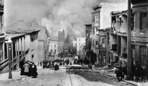
At the time of 5:12 a.m. on the day of Wednesday, April 18, 1906, the coast of Northern California was hit by a big earthquake with a calculated moment magnitude of 7.9 and the highest Mercalli intensity of XI (Extreme).
High-intensity vibration was observed from Eureka on the North Coast to the Salinas Valley, an agricultural area to the south of the San Francisco Bay area.
Destructive fires soon busted out in San Francisco and stayed for many days. Around More than 3,000 people lost their lives, and over 80% of the city was damaged partially. The 1906 San Francisco Earthquake is recognized as one of the most destructive and fatal earthquakes in the history of the United States.
The casualty count stays the greatest casualty of life from a natural disaster in California’s history and is high on the list of American disasters.
2. Aftershock
The main shock was heeded by multiple aftershocks. As with the 1857 Fort Tejon tremor, there were rarer aftershocks than would have been predicted for a shock of that size. Very few of them were discovered across the trace of the 1906 fracture, managing to focus near the ends of the fracture or on other structures, out from the San Andreas Fault itself, such as the Hayward Fault.
The only aftershock in the first few days of near Magnitude of 5 or greater happened near Santa Cruz at 14:28 PST on April 18, with a magnitude of about 4.9 Magnitude Intensity. The biggest aftershock occurred at 01:10 PST on April 23, west of Eureka, California, with a calculated magnitude of about 6.7 MI , with another of the identical size more than three years after at 22:45 PST on October 28 close to Cape Mendocino.
It contains an earthquake swarm in the Imperial Valley region, which peak in an earthquake of about 6.1 MI at 16:30 PST on April 18, 1906. Another event of a similar type appeared at 12:31 PST on April 19, 1906, with an evaluated magnitude of about 5.0 MI , and an epicenter underneath Santa Monica Bay.
3. Tectonics Plate in the USA
The North American Plate is a tectonic plate surrounding the major of North America, Cuba, the Bahamas, outermost northeastern Asia, and regions of Iceland and the Azores. Having an area of 76 million km2 (29 million sq mi), it is the Earth’s second-largest tectonic plate, after the Pacific Plate (which borders the plate to the west).

Alaska and California face more tremors and more powerful earthquakes than any other United State America state.
Like all transform plate boundaries, the San Andreas is a strike-slip fault, motion across which is predominant horizontal. Specifically, the San Andreas fault zone diverges the Pacific and North American Plates, which are gradually grinding further each other in a roughly north-south direction.
4. Tectonics Plate All Over The World
There are several plates categorized as major, minor and micro tectonic plates.
There are seven major plates which are as follows:
a. African
b. Antarctic
c. Eurasian
d. Indo-Australian
e. North American
f. Pacific
g. South American.
| Read Also: Formation of Mountains |

